New Publication: How infrastructure projects fail to deliver river understanding, here the example of the Peruvian Amazon Waterway
Several river-related engineering projects lack a comprehensive view to understand a river’s spatial and temporal dynamics. One of these projects is the Amazon Waterway (Hidrovía Amazónica in Spanish) which sought to strengthen commercial transport between Brazil and Peru using four rivers: Amazon, Ucayali, Marañón, and Huallaga. The Terms of Reference (TOR) for the Environmental Impact Study (EIA) did not specify the methodology for understanding river dynamics; however, the focus was mainly concentrated on the need to develop dredging activities. During the EIA evaluation stage, more than 400 technical observations were presented, several related to fluvial geomorphology.
Our recent publication, “Hydrogeomorphic Characterization of the Huallaga River for the Peruvian Amazon Waterway”, synthesizes how proper river studies should be carried out and how river dynamics is related to aquatic biodiversity, highlighting the importance of understanding rivers before developing infrastructure projects.
Methodology
Using a combination of remote sensing techniques, hydro-geomorphological measurements, and interpretation of physical processes in the Huallaga River from Yurimaguas to its confluence with the Marañón River. The characterization of modern river dynamics followed the methodology presented by Abad et al (2022) and Abad et al (2023). Similarly, ancient river dynamics were delimited by combining digital elevation, satellite, and radar images, focusing on erosion zones and deposition areas along the channels, similar to Rojas et al (2023).
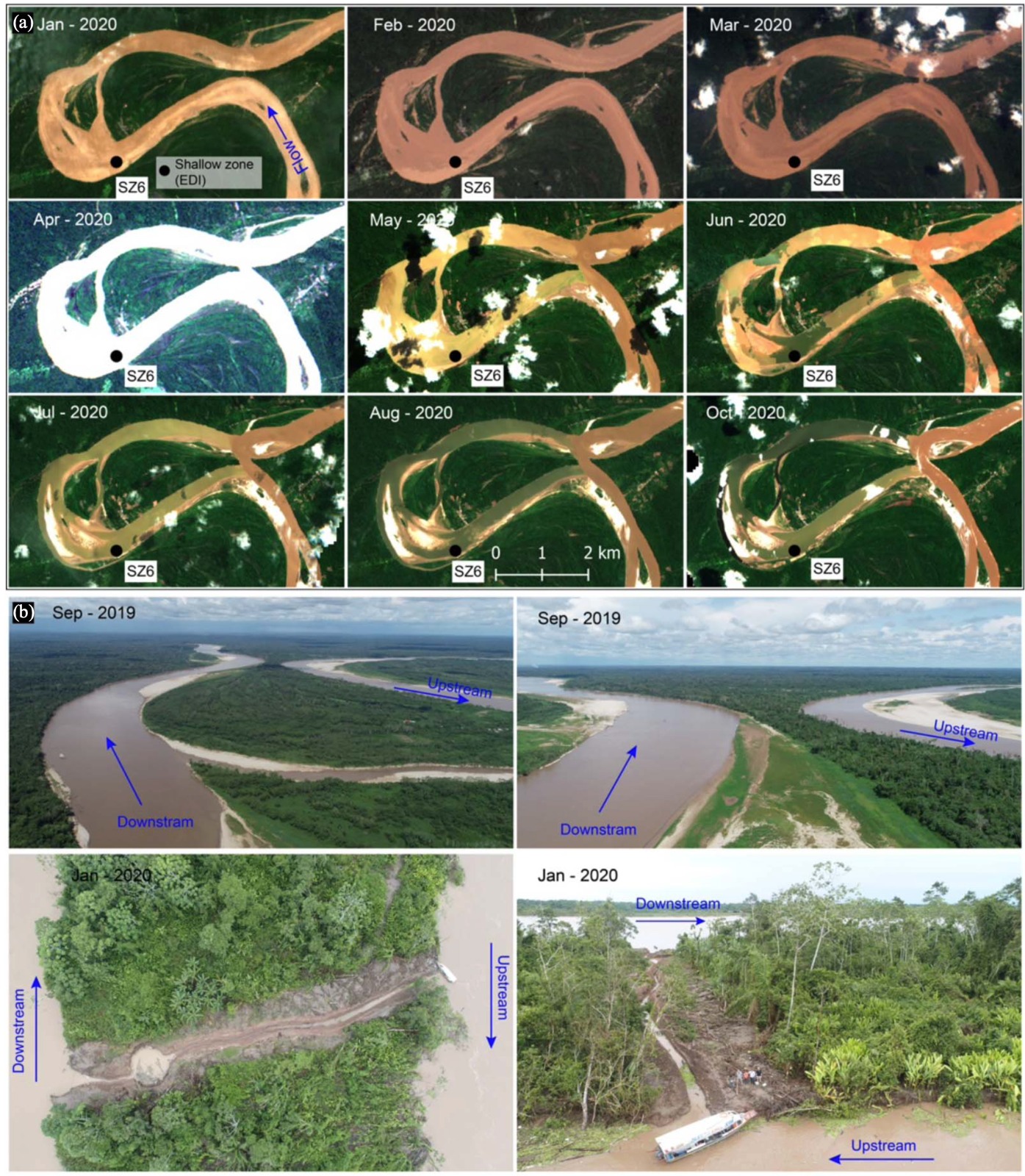
The hydro-geomorphological measurements made it possible to obtain detailed three-dimensional hydrodynamics and sediment transport processes (suspended and bedload), as well as the bathymetry of the area where there are shallow zones (dredging zones). These measurements were complemented with drone flights to obtain a better perspective, especially to understand the measurements around meander cutoffs, which modify the hydrodynamic patterns, including the geomorphology of the river, having influences upstream and downstream of the neck cutoff. (Li et al. 2023)
Results
This study presents an integral methodology for the hydrogeomorphic characterization of the meandering Huallaga River (the river with 56% of the total estimated volume to dredge) by using remote sensing and field measurements (hydrodynamic, sediment transport, and bathymetry).
Geological confinement of river dynamics, together with the presence of anabranching structures, promotes stable shallow zones. In regions where meandering rivers tend to develop ancient and modern geomorphic structures, shallow zones are temporarily and highly dependent on river dynamics. The present hydrogeomorphic characterization of the Huallaga River will support the Peruvian government to inform their technical guidelines, especially for infrastructure projects in Amazonian rivers.
Cover figure: Cutoff at Progreso, Río Huallaga. Figure from Valverde et al (2024)
Citation
Valverde, H., Abad, J.D., Guerrero, L., Estrada, Y., Frias, C. (2024). Hydrogeomorphic Characterization of the Huallaga River for the Peruvian Amazon Waterway. Journal of Waterway, Port, Coastal, and Ocean Engineering, 150 (2).